Category:'s-Gravenweg 229, Capelle aan den IJssel
Jump to navigation
Jump to search

| Object location | | View all coordinates using: OpenStreetMap - Google Earth - Proximityrama |
|---|
 | |||||
| Instance of | house | ||||
| Location | Capelle aan den IJssel, South Holland, Netherlands | ||||
| Located at street address |
| ||||
| Heritage designation |
| ||||
| |||||
|
|
|||||
|
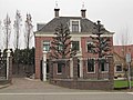
This is a category about rijksmonument number 11469 |
Address
| 's-Gravenweg 229 Capelle aan den IJssel Netherlands |
Media in category "'s-Gravenweg 229, Capelle aan den IJssel"
The following 3 files are in this category, out of 3 total.
 Middenpartij - Capelle aan den IJssel - 20046577 - RCE.jpg 1,200 × 809; 234 KB
 RM11469 Capelle aan den IJssel - 's Gravenweg 229.jpg 2,592 × 1,944; 1.4 MB
 Veldzicht", vooraanzicht - Capelle aan den IJssel - 20046578 - RCE.jpg 1,200 × 811; 228 KB

