Category:'s-Gravenweg 3, Nieuwerkerk aan den IJssel
Jump to navigation
Jump to search

| Object location | | View all coordinates using: OpenStreetMap - Google Earth - Proximityrama |
|---|
 | |||||
| Instance of | farmhouse | ||||
| Location | Zuidplas, South Holland, Netherlands | ||||
| Located at street address |
| ||||
| Heritage designation |
| ||||
| |||||
|
|
|||||
|
This is a category about rijksmonument number 30440 |
Address
| 's-Gravenweg 3 Nieuwerkerk aan den IJssel Netherlands |
Media in category "'s-Gravenweg 3, Nieuwerkerk aan den IJssel"
The following 2 files are in this category, out of 2 total.
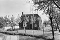 Aanzicht - Nieuwerkerk aan den IJssel - 20164640 - RCE.jpg 1,200 × 812; 290 KB
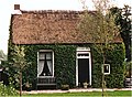 Rijksmonument-30440.jpg 1,445 × 1,057; 572 KB
