Category:'t Boshuis (Drie)
Jump to navigation
Jump to search

| Object location | | View all coordinates using: OpenStreetMap - Google Earth - Proximityrama |
|---|
 | |||||
| Instance of | architectural structure | ||||
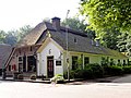
| Location | Ermelo, Gelderland, Netherlands | ||||
| Located at street address |
| ||||
| Heritage designation |
| ||||
| |||||
|
|
|||||
|
This is a category about rijksmonument number 15363 |
Address
| Sprielderweg 205 Drie Netherlands |
Media in category "'t Boshuis (Drie)"
The following 8 files are in this category, out of 8 total.
 Boshuis 1923.jpg 1,413 × 843; 728 KB
 Boshuis Drie.jpg 1,600 × 1,200; 370 KB
 Boshuis in Drie.jpg 3,648 × 2,736; 991 KB
 Herberg in Drie (met kapel?) (30651644170).jpg 3,872 × 2,592; 4.73 MB
 Interieur Boshuis Drie.jpg 3,648 × 2,736; 857 KB
 Sprielderweg 205, 't Boschhuis 1765 - Drie - 20063848 - RCE.jpg 1,200 × 806; 200 KB
 Tegel Boshuis Drie.jpg 3,648 × 2,736; 258 KB
 Tegelwand Boshuis Drie.jpg 2,224 × 2,384; 486 KB


_(30651644170).jpg)


