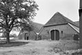
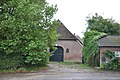
Category:'t Hoen, Voorst
Jump to navigation
Jump to search

| Object location | | View all coordinates using: OpenStreetMap - Google Earth - Proximityrama |
|---|
 | |||||
| Instance of | farm | ||||
| Location | Voorst, Gelderland, Netherlands | ||||
| Located at street address |
| ||||
| Heritage designation |
| ||||
| |||||
|
|
|||||
Nederlands: 't Hoen
|
This is a category about rijksmonument number 38036 |
Address
| Hoenweg 9 Voorst Netherlands |
Media in category "'t Hoen, Voorst"
The following 3 files are in this category, out of 3 total.
 't Hoen", achter - Voorst - 20246661 - RCE.jpg 1,200 × 810; 265 KB
 't Hoen", vooraanzicht (1766) - Voorst - 20246660 - RCE.jpg 1,200 × 811; 230 KB
 Voorst, 38036.JPG 4,288 × 2,848; 6.3 MB

_-_Voorst_-_20246660_-_RCE.jpg)