Category:'t Klooster 4, Giethoorn
Jump to navigation
Jump to search

| Object location | | View all coordinates using: OpenStreetMap - Google Earth - Proximityrama |
|---|
 | |||||
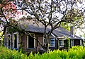
| Instance of | farmhouse | ||||
| Location | Steenwijkerland, Overijssel, Netherlands | ||||
| Located at street address |
| ||||
| Heritage designation |
| ||||
| |||||
|
|
|||||
|
This is a category about rijksmonument number 10512 |
Address
| 't Klooster 4 Giethoorn Netherlands |
Media in category "'t Klooster 4, Giethoorn"
The following 4 files are in this category, out of 4 total.
 Aanzicht - Giethoorn - 20078361 - RCE.jpg 1,200 × 809; 306 KB
 TKlooster 4 Giethoorn.jpg 3,522 × 2,454; 1.41 MB
 Zij- en voorgevel nr. 21642 - Giethoorn - 20507703 - RCE.jpg 1,200 × 900; 154 KB
 Zij- en voorgevel nr. 21643 - Giethoorn - 20507704 - RCE.jpg 1,200 × 900; 164 KB


