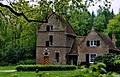
Category:'t Olde Spiker (Hattem)
Jump to navigation
Jump to search

| Object location | | View all coordinates using: OpenStreetMap - Google Earth - Proximityrama |
|---|
 | |||||
| Location | Hattem, Gelderland, Netherlands | ||||
| Located at street address |
| ||||
| Heritage designation |
| ||||
| |||||
|
|
|||||
Nederlands: 't Olde Spiker
|
This is a category about rijksmonument number 20991 |
|
This is a category about rijksmonument number 530476 |
Address
| Veldweg 14 Hattem Netherlands |
Media in category "'t Olde Spiker (Hattem)"
The following 13 files are in this category, out of 13 total.
 't Olde Spiker (31276324366).jpg 4,000 × 3,000; 4.17 MB
 Exterieur overzicht achtergevel - Hattem - 20103188 - RCE.jpg 1,200 × 971; 257 KB
 Exterieur overzicht voorzijde - Hattem - 20103189 - RCE.jpg 1,200 × 951; 333 KB
 Op het Landgoed Molecaten - Hattem - 20103194 - RCE.jpg 1,200 × 801; 272 KB
 Overzicht achterzijde - Hattem - 20103184 - RCE.jpg 1,200 × 954; 375 KB
 Overzicht van het huis met brug op de voorgrond - Hattem - 20415553 - RCE.jpg 1,200 × 943; 304 KB
 Overzicht voorzijde met bebouwing - Hattem - 20103186 - RCE.jpg 1,200 × 956; 343 KB
 Spijker Watervliedt.jpg 977 × 1,521; 1.5 MB
 Vooraanzicht - Hattem - 20103187 - RCE.jpg 959 × 1,200; 326 KB
 Watervliet.jpg 1,989 × 1,283; 531 KB
 Watervliet1.jpg 2,000 × 1,290; 1.89 MB
 Zij- en achtergevel - Hattem - 20103185 - RCE.jpg 957 × 1,200; 348 KB
.jpg)


