Category:Atlas of North America
Jump to navigation
Jump to search


|
Wikimedia Commons Atlas of the World The Wikimedia Atlas of the World is an organized and commented collection of geographical, political and historical maps available at Wikimedia Commons. Discussion • Update the atlas • Index of the Atlas • Atlas in categories • Other atlases on line |
The introductions of the country, dependency and region entries are in the native languages and in English. The other introductions are in English.
Subcategories
This category has only the following subcategory.
C
Pages in category "Atlas of North America"
The following 54 pages are in this category, out of 54 total.
B
C
G
N
S
Media in category "Atlas of North America"
The following 21 files are in this category, out of 21 total.
 13 colonies in 1775 (large).png 442 × 655; 67 KB
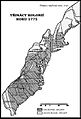 13 colonies in 1775 cs.jpg 455 × 669; 162 KB
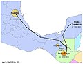 HuastecRoute.jpg 780 × 603; 48 KB
 Location North America.svg 550 × 550; 455 KB
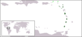 LocationOECS.PNG 250 × 115; 7 KB
 Map of CARICOM.PNG 332 × 409; 10 KB
 Map of Mexico 1847.jpg 3,000 × 2,138; 1.87 MB
 N. Am. frm space.PNG 535 × 535; 287 KB
 Noord-Amerika reliëf.jpg 664 × 501; 55 KB
 North America (orthographic projection).svg 550 × 550; 457 KB
 North America 368x348.png 368 × 348; 48 KB
 North America ortho.png 360 × 360; 68 KB
 North America-ru.png 944 × 1,262; 1.26 MB
 North america98.svg 8,000 × 3,486; 4.54 MB
 North-America (transparent).png 590 × 350; 7 KB
 North-America.png 621 × 335; 11 KB
 NorthAmerica.png 826 × 498; 58 KB
 US map - rivers and lakes.png 1,584 × 1,224; 301 KB
 US map - states and capitals.png 5,499 × 4,249; 3.27 MB
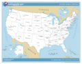
 US map - states.png 1,478 × 1,001; 356 KB
 USA-satellite.jpg 1,082 × 675; 391 KB
.png)


.svg)


.png)


