Category:Political geography
Jump to navigation
Jump to search

| Category Political geography on sister projects: | |||||||||
|---|---|---|---|---|---|---|---|---|---|
| Subclass of | geography | ||||
| Part of | human geography | ||||
| |||||
Subcategories
This category has the following 29 subcategories, out of 29 total.
*
B
C
D
E
F
G
H
I
M
N
P
R
S
T
U
Media in category "Political geography"
The following 64 files are in this category, out of 64 total.
 1921 Decree on Polish as state language in Volyn Voyvodeship.jpg 1,366 × 926; 648 KB
 2004 Worldwide Energy Sources graph.png 688 × 599; 9 KB
 2004 Worldwide Energy Sources graph.svg 688 × 599; 29 KB
 Administración territorial de Colombia.svg 1,231 × 610; 17 KB
 Administración territorial francesa es.svg 685 × 460; 8 KB
 Administrativ Ënnerdeelung vun Däitschland.svg 1,037 × 519; 1.33 MB
 Administrative Gliederung Deutschlands (KO).svg 1,037 × 519; 1.33 MB
 Administrative Gliederung Deutschlands 1 Norwegisch (bokmål).svg 1,037 × 519; 1.33 MB
 Administrative Gliederung Deutschlands la.svg 1,037 × 519; 1.33 MB
 Administrative Gliederung Deutschlands-hy.png 1,264 × 632; 22 KB
 Administrative Gliederung Deutschlands-ja.svg 1,037 × 519; 1.33 MB
 Administrative Gliederung Deutschlands.png 1,264 × 632; 25 KB
 Administrative Gliederung Deutschlands.svg 1,037 × 519; 1.32 MB
 Capital not largest city-2010-24-12.png 1,357 × 628; 49 KB
 Capital not largest city.PNG 1,357 × 628; 27 KB
 Capital not largest city.svg 1,035 × 531; 1.41 MB
 Ceilão.png 694 × 877; 22 KB
 Colonization 1945 he.PNG 800 × 370; 105 KB
 Colonization of the Americas 1750 id.PNG 470 × 623; 17 KB
 Cyclone2A1999Pak.jpg 512 × 562; 39 KB
 Dezentral2.jpg 1,485 × 1,208; 45 KB
 Dezentral3.jpg 1,485 × 1,208; 43 KB
 División administrativa Alemania 1024px.png 1,024 × 512; 68 KB
 Eagles against the other economic concepts e.JPG 2,166 × 813; 821 KB
 EAGLEs ex Chinindia e.JPG 819 × 766; 327 KB
 EAGLEs vs G7 e.JPG 832 × 761; 194 KB
 Electoral systems for heads of state map.svg 863 × 443; 1.67 MB
 Electoral systems map for upper houses.svg 863 × 443; 1.66 MB
 Electoral systems map.svg 863 × 443; 1.28 MB
 Emerging Countries.png 1,900 × 900; 259 KB
 Epirote women Aug1914.jpg 797 × 468; 247 KB
 Gemeinden Freiburg.png 1,103 × 809; 93 KB
 Gemeinden Schweiz.png 1,088 × 729; 67 KB
 Gemeinden Tessin.png 1,043 × 774; 80 KB
 Gerrymander3.svg 1,350 × 432; 23 KB
 Ice camp Barneo.jpg 2,272 × 1,704; 740 KB
 INSEE-ville-metropole-FR.png 360 × 431; 31 KB
 LocationRwandaBurundi.PNG 250 × 115; 6 KB
 Map of unitary and federal states.svg 863 × 443; 1.54 MB
 Map of unitary states.png 800 × 411; 95 KB
 Map of unitary states.svg 863 × 443; 1.54 MB
 Niedersachsensymbol.PNG 300 × 299; 101 KB
- Nl-Leefbaren-article.ogg 8 min 8 s; 4.82 MB
 OrganizaciónColombia.png 620 × 650; 53 KB
 Ostheimexclave2.jpg 352 × 385; 28 KB
 PanhandleMap-USA-states.png 841 × 580; 28 KB
 Pas drogi granicznej.jpg 1,600 × 1,200; 704 KB
 Pendón morado.jpg 400 × 242; 19 KB
 PivotofHistory(1904).png 1,310 × 806; 2.17 MB
 PivotofHistory(1943).png 1,248 × 687; 1.8 MB
 Portada mapa e.JPG 1,766 × 917; 521 KB
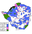 Rhodesialand Arabic.png 699 × 747; 200 KB
 Rundplatzdorf.svg 480 × 400; 3 KB
 Samaria, Jordan-Israel border.gif 1,704 × 1,506; 109 KB
 South Moluccas (orthographic projection).png 1,000 × 1,000; 195 KB
 Správní dělení Saska.svg 738 × 572; 69 KB
 Structure administrative territoriale allemande.svg 1,053 × 531; 1.1 MB
 Subdivisiones de Colombia.svg 1,030 × 1,109; 20 KB
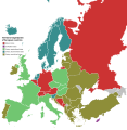 Territorial organization of European countries.svg 593 × 606; 709 KB
 UK Persian Gulf.jpg 813 × 888; 75 KB
 UN Persian Gulf.jpg 1,200 × 826; 304 KB
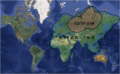
 Western world according Statistics Norway.png 4,430 × 2,200; 251 KB
 Адміністративний поділ Німеччини.svg 1,037 × 519; 1.33 MB
 Административное деление ФРГ.svg 1,037 × 519; 1.32 MB


.svg)
.svg)


.png)
.png)


.png)


