Commons:Graphic Lab/Map workshop
| Illustration Workshop | Map Workshop | Photography Workshop | Video and Sound Workshop |
 Map workshop
This workshop is part of the Graphics Lab, a project aimed at picture retouching to improve the graphical content of the Wikimedia projects. More information about the lab can be found on its main page and requests pages (Illustrations ; Photographs ; Maps ; Video and Sound). To ask questions or make a suggestions, see the talk page of the graphic lab page.
This specific page is the requests page for the Map Workshop. Anyone can make a request for a map to be created or improved. The standard format for making a request is shown below, along with general advice, and should be followed.
Make a request
Use the following template when making a new request, replacing the examples with your image(s) and request(s):
<gallery>
 IMAGENAME.EXT|Description of image
 IMAGE#TWO.EXT|2nd image (If there is one)
 ETCETCETC.EXT|Don't request too many at once, though
</gallery>

;Request:
: Details of your request go here… --~~~~
;Graphist opinion(s):
See also[edit]
| ||||||
| SpBot archives all sections tagged with {{Section resolved|1=~~~~}} after 7 days and sections whose most recent comment is older than 185 days. For the archive overview, see /Archive. The latest archive is located at /Archive/2018. |
Contents
- 1 Map workshop
- 2 Location maps of Sri Lanka
- 3 Sri Lankan province and district location maps
- 4 Browser Market Map
- 5 Iranian Presidential Election Results
- 6 African colonies
- 7 Moroccan regions and provinces locator maps
- 8 U.S. counties
- 9 Divide blank world map with subdivisions by continents
- 10 north polar azimuthal equidistant projection world map
- 11 Limassol District
- 12 Minor modifications to 2006 CIA Somalia base map
- 13 Geographical range of grey wolf and golden jackal together
- 14 Location map
- 15 Three U.S.-related requests
- 16 Biome of Australia
- 17 Right-wing populist parties in Europe, Dec. 2017
- 18 South Sudan (and if it is also missing, Montenegro) urgently needs to be included in these blank world maps
- 19 SVG map for File:Esperanza de vida.PNG
- 20 Borders of South Sudan
- 21 Free_State_of_Fiume
- 22 Greater Armenia
- 23 Saint Pierre and Miquelon
- 24 Kyshtym disaster
- 25 Font Request
- 26 French version of File:Air_Canada_Flight_797_seat_injury_chart.svg
- 27 Aegean Sea
- 28 Location maps Norway
- 29 Metrication by year
- 30 Mizoram district maps
- 31 Maps of Poland, Russia and Lithuania
- 32 Translate the file into Malay language
- 33 Political divisions of Mexico 1865
- 34 British India
- 35 Lamu
- 36 Free_State_of_Fiume
- 37 Greater Armenia
- 38 Kyshtym disaster
- 39 Germans attacks on Nauru-en.svg
- 40 Bad river name for early modern Europe map
- 41 Fixing an Alaska locator map
- 42 Looking for a tutor
- 43 Create a map using gpx data
- 44 Physical map of Peru, with source for the underlying topographical information
Location maps of Sri Lanka[edit]

(1)
Main location map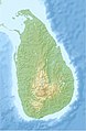
(2)
Main location map (relief)
(3)
NASA topography map


- Article(s)
- en:Template:Location map Sri Lanka
- en:Module:Location map/data/Sri Lanka Northern Province
- (more modules to be created)
- Request
- Replace the topography detail of the existing relief map (2nd file), with that of the more accurate and detailed NASA map (3rd file). (recolouring will be needed)
- Sharpen the provincial and district borders with those as shown on
files 4 and 5file 6. These two files are samples only, and are to be deleted. - Fix borders on the relief map (top area - 2nd file).
- Make provincial borders thicker than district borders.
- Remove the two rivers and reservoirs from the first two maps (see also), and
- If needed, you may visit this page to test the accuracy of the country's borders. The placemark's coordinates are very accurate (taken from Google Earth), and shows the extreme ends of the country. Thanks! Rehman 05:33, 25 March 2016 (UTC)
- Graphist opinion(s)
Sri Lanka adm location map.svg and Sri Lanka rel location map.svg are available now. NNW 21:20, 18 May 2016 (UTC)
- Thank you, NNW! Looks great! Just a few changes, would you be able to remove all the rivers and waterbodies from both new maps, and make the 2nd level (district) borders more lighter (lighter grey)? And instead of just trashing the river details which I just mentioned, would you be able to upload it to a completely new svg file using the topographic background, and including only rivers and 1st level/province borders, but no waterbodies. This will be very useful for the river articles which I am currently working on. Thank you so much for your help. Cheers, Rehman 01:30, 21 May 2016 (UTC)
- Deleting all lakes? Some rivers flow through lakes. Sri Lanka adm location map.svg and Sri Lanka rel location map.svg are showing only 1st level borders now, Sri Lanka adm-2 location map.svg and Sri Lanka rel-2 location map.svg 2nd level borders, too, with these borders with a thiner line. All these maps are part of a set of maps which all have to look the same. I can upload further files but they won't have file names related to location maps but you can use them as alternative maps for the template maps. NNW 16:58, 23 May 2016 (UTC)
@NNW: Sorry for the late reply. Please ignore my previous comment. Instead, would you be able to replace File:Sri Lanka location map.svg with File:Sri Lanka adm-2 location map.svg, but removing all the rivers while retaining the water bodies? This is because the current default map:
- does not have the waterbodies marked properly
- has no distinction between provinces and district borders
- and has less sharper borders when compared to the map you created.
Removal of rivers is because:
- the current map doesn't have rivers
- not all rivers are mapped
- having rivers will confuse viewers for borders, and looks too cluttered as well.
Similarly, the same applies to the relief maps (File:Sri Lanka relief location map.jpg and File:Sri Lanka rel location map.svg), but to add district borders as well. Please let me know if this is possible. Thank you, Rehman 14:00, 7 July 2016 (UTC)
Sri Lankan province and district location maps[edit]
Article(s): Numerous Sri Lankan articles
- Request
- Currently only two of the nine provinces and one of the twenty five districts have location maps. It would be great if the remainder also had location maps. I appreciate this is a big ask but anything would be appreciated.--Obi2canibe (talk) 12:24, 8 September 2016 (UTC)
- Graphist opinion(s)
- Non-graphist comment: The same outcome is requested in part of the #Location maps of Sri Lanka section above. Rehman 13:10, 8 September 2016 (UTC)
- That request relates to island wide maps - my request is for province/district specific maps.--Obi2canibe (talk) 13:14, 8 September 2016 (UTC)
- Obi2canibe and Rehman This may not answer all your map needs but there is now a way of using and annotating Open Street Maps, which can provide a different way of showing map data without each map having to be made specially. It won't integrate into info-boxes and uses a template at en:template:OSM Location map which might need porting across to non-en wiki's. But as an example, I have added a map at en:Sabaragamuwa Province to show an example of what is possible. It could also be used to add red locator dots etc to show specific features. (Unfortunately the Open Street Map version available does not currently show Sri Lanka district boundaries}. RobinLeicester (talk) 21:31, 2 January 2017 (UTC)
- Thanks RobinLeicester, that's great news! Rehman 14:52, 3 January 2017 (UTC)
Browser Market Map[edit]
Article(s): en:Usage share of web browsers
- Request
- May you please do an updated map from Statcounter data? The July 2016 file is corrupt.--Kopiersperre (talk) 15:19, 9 November 2016 (UTC)
- Graphist opinion(s)
@Kopiersperre: Do you want a new map for July 2016?
The time span you linked to say something different and other type of map. Is this what you want gs.statcounter.com please ping me, thanks. --Goran tek-en (talk) 14:49, 29 January 2018 (UTC)
Iranian Presidential Election Results[edit]

Map of Iranian presendtions election by province.

Map of Iranian presendtions election by province.


Article(s): ar:انتخابات إيران الرئاسية 2017
- Request
Remove the English text form the image, so it can be used in all wiki languages. If this is not available, for a reason or another, Arabic text will be great.--Aladdin (talk) 21:54, 20 May 2017 (UTC)
- Graphist opinion(s)
-
- I will upload a version without any texts after official results per province come out. Ali 18:04, 21 May 2017 (UTC)
African colonies[edit]

example for the en:Belgian Congo

Example for the en:French Algeria
Example for the en:French protectorate in Morocco


.svg)
Article(s): es:Congo Belga, es:Protectorado francés de Marruecos, es:Colonización francesa de Argelia and the respective article in each language.
- Request
- Hi, do you can do a map of this three colonial territories, in the case of the Belgian Congo it exist one but it has a very lower quality.--Fr2002 (talk) 21:52, 10 June 2017 (UTC)
- Graphist opinion(s)
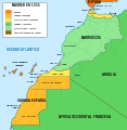
Moroccan regions and provinces locator maps[edit]

The old administrative division of Morocco (1997), region of en:Tangier-Tetouan shown in the map.

The new administrative division of Morocco (2015), region of en:Tanger-Tetouan-Al Hoceima shown in the map.

.svg)


Article(s): en:Regions of Morocco and articles of every region in Morocco and many more.
- Request
- Can you please (if you have time of course) update the locator maps of the regions of Morocco based on the new administrative division of 2015. There was 16 regions before the new division, and now there is 12. you can find here good maps to rely on when making the maps. Thank you.--أنس (talk) 01:50, 26 August 2017 (UTC)
- Graphist opinion(s)
@أنس: Can you please list (with links) to each one of the svg maps you want updated, and provide me with one svg source which is correct.
Do you want the new maps uploaded as a new version of the previous ones or as new maps? Please ping me, thanks. --Goran tek-en (talk) 17:52, 19 October 2017 (UTC)
U.S. counties[edit]
- United States counties, with territories.svg
SVG map of U.S. counties including municipalities of Puerto Rico, and the rest of the U.S. territories.
- Request
- Could someone create a blank map of U.S. counties based off of File:USA counties white borders.svg, including municipalities of Puerto Rico and U.S. territories? I've tried to do this myself a few times but the file's always become corrupted. --MB298 (talk) 04:03, 9 October 2017 (UTC)
- Graphist opinion(s)
@MB298: If you have created File:USA counties white borders.svg can't you just add the territories you need from this file file:Blank_USA,_w_territories.svg? If that new file gets corrupted maybe I can try to help you with that. Please ping me if you want to contact me, thanks. --Goran tek-en (talk) 17:34, 18 December 2017 (UTC)
Divide blank world map with subdivisions by continents[edit]

Blank Map of the World

example/style 1
example/style 2

Example/style 3
_(special_marker)_(-mini_map_-rivers).svg)

Article(s):
- Request
- Hola estimados, quiero pedirles que dividan el mapa por continentes con uno de los dos estilos (style 1 o style 2 o 3) para que puedan verse mejor el mapa y más cerca. Sería útil para algunos artículos que existen. Al menos lo pido para Norteamerica (que incluido Centroamerica y el Caribe además de Groenlandia y Hawaii) porque hay otro similar pero siempre le falta uno que otro "territorio". Pueden hacerlo PNG o SVG, como gusten-
- Is there news? --189.230.76.133 14:30, 18 March 2018 (UTC)
- Details of your request go here… --189.238.82.187 01:35, 5 November 2017 (UTC)
- Graphist opinion(s)
north polar azimuthal equidistant projection world map[edit]

one of several files I intend to replace the map outline in

Article(s): en:flag of the United Nations
- Request
- Currently several files that include the UN emblem contain poorly autotraced outlines (even the meridians and parallels are mashed in!). I intend to fix this and have capable vector manipulation skills, but am pretty lost as far as cartography goes (I have QGIS but no idea how to use it to make a particular projection and no idea even where to get coast and lake outline data in the first place) so I thought I would ask you Wiki[carto]graphists! All I need is the appropriate vectors and then I can edit them into the various files. As far as specifications go, the official flag description in UN document A/107 (https://documents-dds-ny.un.org/doc/UNDOC/GEN/NL4/604/21/pdf/NL460421.pdf) is "A map of the world representing an azimuthal equidistant projection centred on the North Pole [...] The projection of the map extends to 60 degrees south latitude [...]" Thanks. Arlo James Barnes 01:33, 28 December 2017 (UTC)
- Graphist opinion(s)
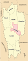
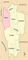
Limassol District[edit]
- IMAGE1.EXT
Description of first image
- IMAGE2.EXT
Description of second image (if needed)
- IMAGE3.EXT
Description of third image (if needed; don't request too many at once, though)
Article(s): [[]]
- Request
- Details of your request go here.
Hello. We have File:Cyprus limassol district.svg. I need a similar map, but the map must show the border of the communities. Like File:LimassolDistrict (1).png. I know the border coordinates. Can you help me? I have created File:LimassolDistrict2.svg but I don't know if it is really svg file like the rest location map, and there is no color. Xaris333 (talk) 18:00, 23 January 2018 (UTC)
Οκ. It working. The only problem is the colors. I want to have the same colors as the original not svg file. Xaris333 (talk) 19:42, 23 January 2018 (UTC)
- Graphist opinion(s)
Please use the "Make a new Request" (green) button/link at the top as it gives us all the code we need, thanks. --Goran tek-en (talk) 20:08, 25 January 2018 (UTC)
Minor modifications to 2006 CIA Somalia base map[edit]

2006 Somalia base map

Article(s): en:Somali Armed Forces
- Request
- Details of your request go here: Please modify https://commons.wikimedia.org/wiki/File:Somalia_pol02.jpg with two minor amendments; (1) change "Giohar" to "Jowhar" (en:Jowhar) as this is now the most common name; (2) insert a new location, Adado (en:Adado), in Galgaduud, about half way up the map. Please mark Adado in with a black dot, same style as Ceelbuur, on the road north of Dusa Marreb. The road from Dusa Marreb to Galcaio is basically in three bits; first one that bends slightly to the east, then it bends slightly to the west (bisected by the green dotted line west-east), and then it takes a hard almost 90% turn to the east again. Please mark in Adado half way up the second bit, the one bending to the west, which should be south of the green west-east line. Many thanks!! Buckshot06 (talk) 08:55, 11 February 2018 (UTC)
- Graphist opinion(s)
Geographical range of grey wolf and golden jackal together[edit]

Blank map of Europe with subdivisions as template

Range of golden jackal (please ignore red dots)


Article(s): European jackal
- Request
- A map of Europe with overlapping ranges of grey wolf and golden jackal
- Have the wolf range in brown and the jackal range in dark yellow (something along these lines: File:Distribution of North American Canis.svg ). For an updated European wolf range map, see https://whyfiles.org/2014/europe-return-of-the-carnivores/index.html --Mariomassone (talk) 12:01, 18 February 2018 (UTC)
- Graphist opinion(s)
Location map[edit]

New administrative map of Nepal

Nepal relief location map


en:Province No. 1, en: Administration in Province No. 1
- Request
- Location map for Province No. 1 in Nepal.
- Need a location map for Province No. in Nepal, both adm. and relief. Also need location map for 14 districts in Province No. 1 of Nepal… --Raju Babu (talk) 17:42, 21 February 2018 (UTC)
- Graphist opinion(s)
? You asked me for a location map of Province No. 1 and I made it: Nepal Province No 1 adm location map.svg. NNW 20:31, 21 February 2018 (UTC)
- This map is okay, But may we not have a location map shaded province No. 1 in map of Nepal? You can draw a map of Nepal, in this map Nepal Province No 1 adm location map.svg on the top left corner. Raju Babu (talk) 02:39, 22 February 2018 (UTC)
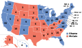
[edit]
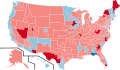
2014 U.S. House election results

Global superpowers in 1945

Legality of Home schooling around the world


Article(s): en:United States House of Representatives elections, 2014, en:Superpower, en:Homeschooling in the United States
- Request
- Image #1: en:New Hampshire's 2nd congressional district is shaded as "Republican gain" even though the Democrat incumbent (en:Ann McLane Kuster) won re-election. Also, en:Illinois's 6th congressional district is shaded as "Democrat hold" even though the Republican incumbent (en:Peter Roskam) won re-election. These errors should be fixed.
- Image #2: The en:Aleutian Islands are shaded red (as though they are part of the USSR) even though they were (and are) part of the United States. This should be fixed.
- Image #3: The U.S. should be colored green on this map, as homeschooling is legal in all 50 states. What is disputed is not the legality of homeschooling, but the "amount of state regulation and help that can or should be expected", according to the article en:Homeschooling in the United States. --1990'sguy (talk) 15:45, 23 February 2018 (UTC)
- Graphist opinion(s)
Biome of Australia[edit]

This the Temperate broadleaf and mixed forests biome.

Mediterranean Forests, woodlands and scrub biome.

Tropical and subtropical dry broadleaf forests biome.


Article(s):
- en:Mediterranean forests, woodlands, and scrub
- en:Temperate broadleaf and mixed forest
- en:Tropical and subtropical dry broadleaf forests
- Request
- As per these sources ([1] - or jump to its map link - and [2]), it is quite clear that most of eastern Australia, besides a few spots, are not under the temperate forest biome. Sydney, for instance, mostly has dry sclerophyl and a few wet sclerophyl places, just akin to Adelaide and Perth. Therefore, it will be more appropriate for the region of Sydney to be under the Mediterranean biome. Furthermore, as you can see from these maps I provided, there are small pockets of temperate and subtropical forests to the north of Sydney. Also, the eastern portion of Melbourne is also dry sclerophyll, meaning it should be under the Med biome as well. I would hope that these are amended, as the original maps are rather fallacious and misleading. Thanks. --Meganesia (talk) 10:07, 24 February 2018 (UTC)
- Graphist opinion(s)
Right-wing populist parties in Europe, Dec. 2017[edit]

Right-wing populist parties in Europe, December 2017
.png)
Article(s): en:Right-wing populism
- Request
- Please shade the UK light blue. As I stated when I requested the Oct. 2017 map be fixed, the en:Democratic Unionist Party is in the parliament and supports the Conservative Party government. The DUP is a right-wing populist party (see here -- source: Ingle, Stephen (2008). The British Party System: An Introduction. Routledge. p. 156.). Also, some factions of the Conservative Party (including some MPs) are right-wing populist.[3]
- Also, maybe Iceland should also be shaded light blue. Since the en:Icelandic parliamentary election, 2017 (held in late-October 2017), two parties that are arguably right-wing populist, the en:People's Party (Iceland, 2016)[4][5] and the en:Centre Party (Iceland), were first elected to the parliament. Most of what I read labels these parties simply as "populist", but both of these parties lean on the right, at least on issues related to nationalism and immigration, and right-wing populism is increasingly being labeled as simply "populism." This isn't as important as my first request, but I think it should still be done. --1990'sguy (talk) 04:10, 6 March 2018 (UTC)
- Graphist opinion(s)
- This map needs more reliable sources in the first place. The only source attributed in the description is Parties and Elections in Europe which does not even label some of the parties mentioned in the map as right-wing populism. Add to that that it appears to be a one-man self-published website. I'd agree with your analysis of the UK though, but this Icelandic source doesn't look very reliable to me. De728631 (talk) 00:45, 5 August 2018 (UTC)
South Sudan (and if it is also missing, Montenegro) urgently needs to be included in these blank world maps[edit]
File:Blank map world gmt.pdf

File:Blank map world gmt (simplified).svg

File:Blank map world gmt (more simplified).svg

File:BlankMap - World - Hellerick polynomial continent-based projection.svg

File:BlankMap-World Default Edition.svg
File:BlankMap-World-162E-flat.svg

File:BlankMap-World-180E.svg

File:BlankMap-World-90W.svg

File:BlankMap-World-large2.png

File:BlankMap-World.svg

File:BlankMap-World5.svg

File:BlankMap-World6-png.png

File:BlankMap-World6.png

File:BlankMap-World7.svg

File:NED worldmap 110m.svg

File:World map (Miller cylindrical projection, blank).svg

File:World map - low resolution chain test.svg

File:World Map Blank.svg

File:World map blank with blue sea.svg

File:World map nations.svg

File:World pacific 0001.svg

File:Worldmap-blank.svg

File:World V2.0.svg


File:Africa mapa mudo.png
File:Blankmap-Africa2.png

File:SVG-Koort Afrika.svg


File:Asia in Th.png
File:Asia location map.svg

File:Asia location map2.svg
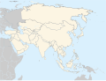
File:Asie.svg
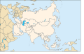
File:Les pays asiatiques - Blank.svg

File:Location Map Asia.svg


Article(s): Many
- Request
- South Sudan (and if it is also missing, Montenegro) urgently needs to be included in these blank world maps, because many users create and upload new maps based on these obsolete maps, without realizing this. Updating all these maps will spare time consuming border changes in the future (and also if new countries become independent in the future). The maps are based on de-jure borders. (I am adding South Sudan (as well as Montenegro and other possible missing updates) in the PNG maps in Category:Maps needing South Sudan political boundaries and then remove this category after updating them. There were close to 1100 maps since I started to update these files, now it is reduced to less than 800 maps, but there is a very long way to go and it is very time consuming and almost never ending, as there are very likely many more unlabeled maps.) --Maphobbyist (talk) 13:37, 10 March 2018 (UTC)
- Graphist opinion(s)
- There's a template for that: {{update|South Sudan}}. I'd recommend adding this to these maps (and any others). I've also noticed that some of these maps have 'South Sudan' mentioned in the file changes; have you checked that these maps need updating prior to putting them in the gallery? Gringer (talk) 21:55, 12 March 2018 (UTC)
SVG map for File:Esperanza de vida.PNG[edit]

SVG map

PNG map


Article(s): Life expectancy
- Request
- Missing SVG map, please convert to SVG. --116.237.18.33 02:32, 1 April 2018 (UTC)
- Graphist opinion(s)
![]() Done I have also updated the map with reliable data from 2015. De728631 (talk) 17:59, 3 August 2018 (UTC)
Done I have also updated the map with reliable data from 2015. De728631 (talk) 17:59, 3 August 2018 (UTC)
Borders of South Sudan[edit]

1st Map

2nd Map

3rd Map

4th Map

Borders of South Sudan


Article(s): Several
- Request
- Can you please add the Borders of South Sudan in the 1st, 2nd, 3rd, and 4th Maps --باسم (talk) 09:55, 1 April 2018 (UTC)
- Graphist opinion(s)
Free_State_of_Fiume[edit]

- Article(s)
- en:Free_State_of_Fiume
- Request
- Please make English version named File:Free_State_of_Fiume_1920-1924.png-the only names needing changed are "Italy" and "Yugoslavia"… --Kintetsubuffalo (talk) 14:04, 5 April 2018 (UTC)
- Graphist opinion(s)
Greater Armenia[edit]

- Article(s)
- en:Greater Armenia
- Request
- please overlay other landmarks like the Caspian or Black Sea, for context… --Kintetsubuffalo (talk) 14:04, 5 April 2018 (UTC)
- Graphist opinion(s)
Saint Pierre and Miquelon[edit]
- Article(s)
- en:Saint Pierre and Miquelon
- Request
- please create closeup map of the islands in relation to Newfoundland. The article has two long-distance maps which show them as specks… --Kintetsubuffalo (talk) 14:04, 5 April 2018 (UTC)
- Graphist opinion(s)
Kyshtym disaster[edit]

- Article(s)
- en:Kyshtym disaster
- Request
- English map, please… --Kintetsubuffalo (talk) 14:04, 5 April 2018 (UTC)
- Graphist opinion(s)
Font Request[edit]

Font used here and the svg copy
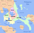
Svg file


Article(s): Cavite province and its local government units
- Request
- I would just like to request for the svg file and font used for this map. Thank you. --HueMan1 (talk) 08:57, 10 April 2018 (UTC)
- Graphist opinion(s)
French version of File:Air_Canada_Flight_797_seat_injury_chart.svg[edit]
Article(s): fr:Vol 797 Air Canada
- Request
- Please make a French version of File:Air_Canada_Flight_797_seat_injury_chart.svg.
The big labels, respectively, should be "Decès," "Survivants," and "Agents de bord".
Smaller:
- aft lavatory -> toilettes à l'arrière
- galley #1 -> office no 1
- galley #2 -> office no 2
- aux. galley -> office auxiliaire
- galley service door -> porte d'service du office
- side window -> fenêtre latérale
- passenger exterior door -> porte passager extérieure
- double flight attendant seat -> siège 2 places de l'agent de bord
- Aft stowage -> arrimage à l'arrière
Thanks! --WhisperToMe (talk) 18:22, 16 April 2018 (UTC)
- Graphist opinion(s)
Aegean Sea[edit]

- Article(s)
- en:Aegean Sea
- Request
- please remove watermark credits top right… --Kintetsubuffalo (talk) 14:59, 27 April 2018 (UTC)
- Graphist opinion(s)
Location maps Norway[edit]

Sortland Municipality
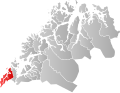
Kvæfjord Municipality
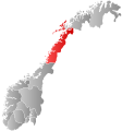
Nordland County

Troms County


Request:
@Jon Harald Søby:, @Marmelad: These maps (and possibly others?) need to be updated. Godfjorden in Kvæfjord became part of Sortland in 2000. Blue Elf (talk) 19:52, 25 May 2018 (UTC)
Metrication by year[edit]
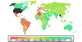
World Map showing metrication

Correct palette/South Sudan boundaries


Article(s): Metrificación, Sistema internazionale di unità di misura and many others
- Update map and friendly coloring
- A lot of work here. It is supposed to be the "replacement map" for metrication pages; nevetheless it has a lot of issues. There are no South Sudan boundaries; the color palette isn't the best for visually impaired people. I'm not good at all at Perl and similar, could you help me? The palette is shown in the second image.--Carnby (talk) 18:04, 28 January 2018 (UTC)
- Graphist opinion(s)
Mizoram district maps[edit]

Saiha district
Serchhip district
Mamit district

Lunglei district

Lawngtlai district

Kolasib district

Aizawl district


Article(s): en:Saiha district, en:Serchhip district, en:Mamit district, en:Lunglei district, en:Lawngtlai district, en:Kolasib district, en:Aizawl district
- Request
- Please fix spelling Champai to Champhai in all as per district official name is en:Champhai district.-- Godric ki Kothritalk to me 12:45, 27 May 2018 (UTC)
- Graphist opinion(s)
Maps of Poland, Russia and Lithuania[edit]


Article(s): en:Kingdom of Poland,, Polish-Lithuaninan Commonwealt, Russian Empire, Muscovy...
- Request
- I don't know source of these maps, it might be still under copyright. It would be nice if we could have free SVG alternatives
- Details of your request go here… -- Bojan Talk 03:01, 28 May 2018 (UTC)
- Graphist opinion(s)
Translate the file into Malay language[edit]
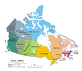
Image requested for translation (Political map of Canada.png)

Article(s): Provinsi dan wilayah di Kanada
- Request
- Hello. Can someone translate the image attached into Malay language (code lang: ms)? The translations are as follow:
- Canada – Political:
- → Kanada – Politik
- International boundary:
- → Sempadan antarabangsa
- Provincial/territorial boundary:
- → Sempadan provinsi/wilayah
- Province/territory:
- → Provinsi/wilayah
- National capital:
- → Ibu negara
- Provincial/territorial capital:
- → Ibu kota provinsi/wilayah
- Scale:
- → Skala
- Northwest Territories:
- → Wilayah Barat Laut
- Newfoundland and Labrador:
- → Newfoundland dan Labrador
- Prince Edward Island:
- → Pulau Putera Edward
- Thank you. 26 Ramadan (talk) 14:41, 1 June 2018 (UTC)
- Graphist opinion(s)
Political divisions of Mexico 1865[edit]


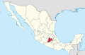
Option 1


.svg)
_in_Mexico.svg)
Article(s): es:Segundo Imperio Mexicano
- Request
- I request an SVG map of the political territorial division of the Second Mexican Empire (1865) with the map design "option 1". If possible, also add some lines to compare the territorial limits of 1865 with the current ones
- Details of your request go here… --Wiki-1776 (talk) 23:13, 7 June 2018 (UTC)
- Graphist opinion(s)
British India[edit]

- Article(s)
- en:British India
- Request
- please remove anachronous Uzbek and Tajik borders, fill in hinterland cities… --Kintetsubuffalo (talk) 01:43, 11 June 2018 (UTC)
- Graphist opinion(s)
Lamu[edit]
- Article(s)
- en:Lamu
- Request
- the map Funguvisiwa vya Lamu.png at https://sw.wikipedia.org/wiki/Funguvisiwa_ya_Lamu#/media/File:Funguvisiwa_vya_Lamu.png may not be allowable here, but the size and detail are great. please make free-use Commons-friendly version … --Kintetsubuffalo (talk) 01:45, 11 June 2018 (UTC)
- Graphist opinion(s)
Free_State_of_Fiume[edit]
- Article(s)
- en:Free_State_of_Fiume
- Request
- Please make English version named File:Free_State_of_Fiume_1920-1924.png-the only names needing changed are "Italy" and "Yugoslavia"… --Kintetsubuffalo (talk) 01:46, 11 June 2018 (UTC)
- Graphist opinion(s)
Greater Armenia[edit]
- Article(s)
- en:Greater Armenia
- Request
- please overlay other landmarks like the Caspian or Black Sea, for context… --Kintetsubuffalo (talk) 01:48, 11 June 2018 (UTC)
- Graphist opinion(s)
Kyshtym disaster[edit]
- Article(s)
- en:Kyshtym disaster
- Request
- English map, please… --Kintetsubuffalo (talk) 01:52, 11 June 2018 (UTC)
- Graphist opinion(s)
Germans attacks on Nauru-en.svg[edit]

Article(s): en:German attacks on Nauru
- Request
- Please correct two typos in Germans attacks on Nauru-en.svg
- Please change "Decembrer1940" to "December 1940" and "17 and 8 December" to "7 and 8 December" (Macedonian version also has this second error) --Davidships (talk) 18:24, 30 June 2018 (UTC)
- Graphist opinion(s)
![]() Done for English and Macedonian. De728631 (talk) 21:02, 2 August 2018 (UTC)
Done for English and Macedonian. De728631 (talk) 21:02, 2 August 2018 (UTC)
Bad river name for early modern Europe map[edit]

Europe, 1700—1714

Article(s): (none)
- Request
- Over Ukraine, we see a river labeled as Dniester. That's actually Southern Bug. Dniester is the next river to the left, at the border of Ukraine and Moldova. Can someone fix? --Gikü (talk) 21:48, 7 August 2018 (UTC)
- Graphist opinion(s)
Fixing an Alaska locator map[edit]

This map is messed up and doesn't display properly

This similar map is fine and may be a good place to start to fix the other one


.png)
Article(s): en:Yakutat, Alaska
- Request
- Just noticed this image is messed up and doesn't display properly. It appears this is true of both the current and earlier verson.
- Reporting in hopes someone can fix it --Pmaccabe (talk) 03:28, 23 August 2018 (UTC)
- Graphist opinion(s)
Looking for a tutor[edit]
For Stolpersteine in Italia I need some maps, pretty simple stuff. I would like to be able to do it on my own. I'm looking for someone who could explain to me the basics of creating a map (different colors for the different regions, highlighting the cities with many Stolpersteine). Thanks in advance.--Meister und Margarita (talk) 15:06, 24 August 2018 (UTC)
Create a map using gpx data[edit]
Hello. I have a gpx file with communities border of my country. Anyone can help me to use it to create a map? Xaris333 (talk) 01:04, 27 August 2018 (UTC)
Physical map of Peru, with source for the underlying topographical information[edit]
- IMAGE1.EXT
Description of first image
- IMAGE2.EXT
Description of second image (if needed)
- IMAGE3.EXT
Description of third image (if needed; don't request too many at once, though)
Article(s): en:Ubinas
- Request
- A physical map of Peru.
- Basically, the same content as File:Peru physical map.svg but from a clearly stated source for the topographic information, as File:Peru physical map.svg states no source and unsourced maps are inadequate for certain enwiki processes. Summoning also Urutseg. --Jo-Jo Eumerus (talk) 07:04, 27 August 2018 (UTC)
- Graphist opinion(s)