File:05june-dow7-wide.gif
Jump to navigation
Jump to search


Size of this preview: 800 × 479 pixels. Other resolutions: 320 × 191 pixels | 640 × 383 pixels | 1,024 × 613 pixels | 1,280 × 766 pixels | 1,912 × 1,144 pixels.
Original file (1,912 × 1,144 pixels, file size: 28.73 MB, MIME type: image/gif, looped, 50 frames, 7.5 s)
Note: Due to technical limitations, thumbnails of high resolution GIF images such as this one will not be animated.
Summary[edit]
| Object location | | View this and other nearby images on: OpenStreetMap - Google Earth |
|---|
| Description |
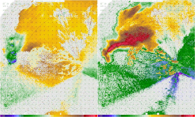
English: A Doppler on Wheels image of a tornadic thunderstorm near La Grange, Wyoming (USA) captured during the VORTEX2 project. In the velocity image on the left, Blues/green represent winds moving towards the radar, and reds/yellows indicate winds moving away from the radar. The reason that some of the darker blues contain red/yellow within them is a trait known as Aliasing, where the winds are moving faster than the radar can detect. In the reflectivity image on the right, the main body of the storm can be seen, with the appendage on the bottom of the storm being a hook echo, which is associated directly with the tornado, and the tornado circulation itself can be seen as the doughnut like shape in the later part of the animation.
Français : Image Radar d'un orage à tornade près de La Grange, dans le Wyoming (États-Unis) prise dans le cadre du projet VORTEX2. L'image de gauche représente la puissance des vents, avec en bleu les vents soufflant vers le radar, et en jaune/rouge ceux qui s'éloignent. Les taches rouges sur fond bleu sont des artefacts (crénelage) dus à des vents soufflant à une vitesse supérieure à la limite de détection du radar. L'image de droite mesure la réflectivité, on peut y voir le nuage d'orage principal, ainsi que l'Écho en crochet du à la tornade elle-même. En fin d'animation, on voit la tornade elle-même, sous la forme d'un anneau brun.
|
|||||||||||||||||
| Date | ||||||||||||||||||
| Source | http://vortex2.org/dowloops/ | |||||||||||||||||
| Author |
|
|||||||||||||||||
| Permission (Reusing this file) |
||||||||||||||||||
| Other versions |
Derivative works of this file: 05june-dow7-wide2.ogv |
|||||||||||||||||

|
Licensing[edit]
|
This file is licensed under the Creative Commons Attribution-Share Alike 3.0 Unported license. | |
|

|
This image has been assessed under the valued image criteria and is considered the most valued image on Commons within the scope: Radar images of thunderstorms. You can see its nomination here. |
File history
Click on a date/time to view the file as it appeared at that time.
| Date/Time | Thumbnail | Dimensions | User | Comment | |
|---|---|---|---|---|---|
| current | 03:28, 15 November 2009 | | 1,912 × 1,144 (28.73 MB) | Ks0stm (talk | contribs) | {{Information |Description={{en|1=A Doppler on Wheels radar loop; velocity on the left, reflectivity on the right.}} |Source=http://vortex2.org/dowloops/ |Author=Joshua Wurman, Center for Severe Weather Research |Date=2009-06-05 |Permission={{OTRS pending |
- You cannot overwrite this file.
File usage on Commons
The following 31 pages uses this file:
- User:Miya/FPs
- User:Miya/FPs/2010/02
- User:Miya/FPs/2010/02/table
- User talk:Ks0stm/Archive 1
- Commons:Featured picture candidates/File:05june-dow7-wide.ogv
- Commons:Featured picture candidates/Log/February 2010
- Commons:Featured pictures/Animated
- Commons:Featured pictures/chronological/2010-A
- Commons:Picture of the Year/2010/Galleries/2010-A
- Commons:Picture of the Year/2010/Galleries/All
- Commons:Picture of the Year/2010/Galleries/Diagrams
- Commons:Picture of the Year/2010/Galleries/Diagrams/Large
- Commons:Picture of the Year/2010/Galleries/Diagrams/Small
- Commons:Picture of the Year/2010/Galleries/Index/2
- Commons:Picture of the Year/2010/Galleries/Index/Animated
- Commons:Picture of the Year/2010/Galleries/Index/Diagrams
- Commons:Picture of the Year/2010/Galleries/Table
- Commons:Picture of the Year/2010/Galleries/Table/02
- Commons:Picture of the Year/2010/R1/File:05june-dow7-wide.gif
- Commons:Picture of the Year/2010/Results/R1/ALL/Table
- Commons:Picture of the Year/2010/Results/R1/Diagrams
- Commons:Picture of the Year/2010/Results/R1/Diagrams/Table
- Commons:Picture of the day/Unused featured pictures
- Commons:Valued image candidates/05june-dow7-wide-gif
- Commons:Valued image candidates/05june-dow7-wide.ogv
- Commons:Valued images by topic/Science/Engineering
- Commons talk:Picture of the Year/2010/Galleries/Table
- Commons talk:Picture of the Year/2010/Results/R1/ALL/Table
- File:05june-dow7-wide.ogv (file redirect)
- File:05june-dow7-wide2.ogv
File usage on other wikis
The following other wikis use this file:
- Usage on en.wikipedia.org
- Hook echo
- Doppler on Wheels
- User:Daniel Mietchen/Science communication gallery
- Wikipedia:Featured picture candidates/Hook echo
- Wikipedia:Featured picture candidates/February-2010
- Wikipedia:Featured picture candidates/September-2012
- Wikipedia:Featured picture candidates/Hook echo 2
- Wikipedia:Featured picture candidates/Hook echo 3
- Wikipedia:Featured picture candidates/May-2017
- Usage on pl.wikipedia.org
- Usage on vi.wikipedia.org