File:1570 borders of the Principality of Transylvania.svg
Jump to navigation
Jump to search


Size of this PNG preview of this SVG file: 600 × 600 pixels. Other resolutions: 240 × 240 pixels | 480 × 480 pixels | 768 × 768 pixels | 1,024 × 1,024 pixels | 970 × 970 pixels.
Original file (SVG file, nominally 970 × 970 pixels, file size: 42 KB)
Summary[edit]
| Description |
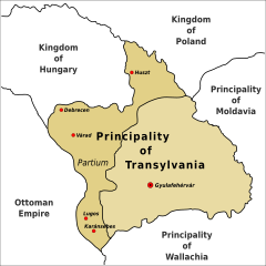
English: Borders of the Principality of Transylvania in 1570, including the area of the Partium.
|
| Date | |
| Source | Own work |
| Author | OSeveno |
| SVG development |
Licensing[edit]
OSeveno, the copyright holder of this work, hereby publishes it under the following license:
|
This file is licensed under the Creative Commons Attribution-Share Alike 4.0 International license. | |
| Attribution: OSeveno | ||
|
File history
Click on a date/time to view the file as it appeared at that time.
| Date/Time | Thumbnail | Dimensions | User | Comment | |
|---|---|---|---|---|---|
| current | 19:51, 26 February 2016 | | 970 × 970 (42 KB) | OSeveno (talk | contribs) | Adjusted text |
| 19:35, 26 February 2016 |  | 970 × 970 (42 KB) | OSeveno (talk | contribs) | User created page with UploadWizard |
- You cannot overwrite this file.
File usage on Commons
The following page uses this file:
File usage on other wikis
The following other wikis use this file:
- Usage on azb.wikipedia.org
- Usage on en.wikipedia.org