File:2008-08-16 Bennett Place historic site.jpg
Jump to navigation
Jump to search


Size of this preview: 800 × 533 pixels. Other resolutions: 320 × 213 pixels | 640 × 427 pixels | 1,024 × 683 pixels | 1,280 × 853 pixels | 3,888 × 2,592 pixels.
Original file (3,888 × 2,592 pixels, file size: 3.71 MB, MIME type: image/jpeg)
|
This is an image of a place or building that is listed on the National Register of Historic Places in the United States of America. Its reference number is 70000452 |
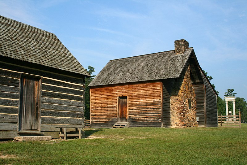
Summary[edit]
| Description |
Deutsch: Bennett Place, ein sorgfältig rekonstruierter, historischer Bauernhof in Durham / North Carolina / USA, jener Ort, an dem die Konföderierten (Südstaaten) während des Amerikanischen Bürgerkriegs am 26. April 1865 ihre größte Niederlage erlitten. Anordnung von links nach rechts: Küche, das Bauernhaus und das Denkmal.
English: Bennett Place, a carefully reconstructed historic farm in Durham, North Carolina, the site of the largest surrender of Confederate soldiers during the American Civil War on April 26, 1865. Showing, from left to right, the kitchen, the farmhouse, and the memorial monument.
Français : Bennett Place, une ferme historique scrupuleusement reconstruite à Durham, en Caroline du Nord (États Unis d'Amérique). Durham est le lieu où s'est déroulée la plus large reddition de troupes sudistes de toute la guerre de sécession, le 26 avril 1865. On peut voir, de gauche à droite, les cuisines, la ferme, et le monument.
|
||
| Date | |||
| Source | Own work | ||
| Author | Ildar Sagdejev (Specious) | ||
| Permission (Reusing this file) |
|

| Camera location | | View this and other nearby images on: OpenStreetMap - Google Earth |
|---|
Licensing[edit]
I, the copyright holder of this work, hereby publish it under the following licenses:

|
Permission is granted to copy, distribute and/or modify this document under the terms of the GNU Free Documentation License, Version 1.2 or any later version published by the Free Software Foundation; with no Invariant Sections, no Front-Cover Texts, and no Back-Cover Texts. A copy of the license is included in the section entitled GNU Free Documentation License. |
|
This file is licensed under the Creative Commons Attribution-Share Alike 4.0 International, 3.0 Unported, 2.5 Generic, 2.0 Generic and 1.0 Generic license. | |
|
You may select the license of your choice.
|

|
This image has been assessed under the valued image criteria and is considered the most valued image on Commons within the scope: Bennett Place. You can see its nomination here. |
| Annotations | This image is annotated: View the annotations at Commons |
File history
Click on a date/time to view the file as it appeared at that time.
| Date/Time | Thumbnail | Dimensions | User | Comment | |
|---|---|---|---|---|---|
| current | 06:14, 14 May 2009 | | 3,888 × 2,592 (3.71 MB) | Specious (talk | contribs) | adjusted levels |
| 18:35, 16 August 2008 |  | 3,888 × 2,592 (3.9 MB) | Specious (talk | contribs) | {{Information |Description={{en|Bennett Place in Durham, North Carolina.}} |Source=Own work |Author=Ildar Sagdejev (Specious) |Date=2008-08-16 |Permission={{User:Specious/Ref}} |other_vers |
- You cannot overwrite this file.
File usage on Commons
The following 9 pages uses this file:
- North Carolina
- User:Specious/QI
- Commons:Featured picture candidates/Image:2008-08-16 Bennett Place historic site.jpg
- Commons:Featured picture candidates/Log/September 2008
- Commons:Quality images/Subject/Architecture/Agricultural and Industrial/Archive
- Commons:Quality images candidates/Archives August 2008
- Commons:Valued image candidates/2008-08-16 Bennett Place historic site.jpg
- Commons:Valued images by topic/Historical/Culture
- Category:Bennett Place
File usage on other wikis
The following other wikis use this file:
- Usage on de.wikipedia.org
- Usage on en.wikipedia.org
- North Carolina
- Bennett Place
- National Register of Historic Places listings in North Carolina
- History of North Carolina
- Wikipedia:Featured picture candidates/September-2008
- Wikipedia:Featured picture candidates/Image:2008-08-16 Bennett Place historic site.jpg
- National Register of Historic Places listings in Durham County, North Carolina
- Troop engagements of the American Civil War, 1865
- 33rd Regiment Alabama Infantry
- Usage on en.wikivoyage.org
- Usage on fr.wikipedia.org
- Usage on ja.wikipedia.org
- Usage on no.wikipedia.org
- Usage on pt.wikipedia.org
- Usage on www.wikidata.org