File:Desna Sosonka 2009 G1.jpg
Jump to navigation
Jump to search


Size of this preview: 800 × 450 pixels. Other resolutions: 320 × 180 pixels | 640 × 360 pixels | 1,024 × 576 pixels | 1,280 × 720 pixels | 3,712 × 2,088 pixels.
Original file (3,712 × 2,088 pixels, file size: 3.26 MB, MIME type: image/jpeg)
Summary[edit]

|
This image has been assessed under the valued image criteria and is considered the most valued image on Commons within the scope: Desna (tributary of the Southern Bug). You can see its nomination here. |
|
| Camera location | | View this and other nearby images on: OpenStreetMap - Google Earth |
|---|
| Object location | | View this and other nearby images on: OpenStreetMap - Google Earth |
|---|
| Description |
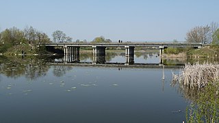
English: The Desna river, feeder of the Southern Bug, in Ukraine. Bridge in Sosonka village. Total length of the Desna river is 80 km, basin area 1400 km².
Français : La Desna, affluent du Boug méridional, au niveau du pont qui la franchit près du village de Sosonka, en Ukraine. La Desna parcourt 80 km, avec un bassin versant de 1400 km². Elle ne doit pas être confondue avec d'autres cours d'eau du même nom (qui signifie main droite), dont la Desna, affluent du Dniepr.
Русский: Река Десна (Десенка), приток Южного Буга. Мост через реку в селе Сосонка Винницкого района Винницкой области.
Українська: Десна, Десенка — ліва притока Південного Бугу. Міст через річку в селі Сосонка Вінницького району.
|
||
| Date | |||
| Source | Own work | ||
| Author | George Chernilevsky | ||
| Permission (Reusing this file) |
|
||
| Other versions |

File history
Click on a date/time to view the file as it appeared at that time.
| Date/Time | Thumbnail | Dimensions | User | Comment | |
|---|---|---|---|---|---|
| current | 07:24, 27 April 2009 | | 3,712 × 2,088 (3.26 MB) | George Chernilevsky (talk | contribs) | {{Information |Description={{en|1=The Desna river, feeder of the the Southern Bug. Bridge in Sosonka village.}} {{ru|1=Река Десна (Десенка), приток Южного Буга. Мост через реку в селе Сосонка Вин |
- You cannot overwrite this file.
File usage on Commons
The following 10 pages uses this file:
- User:George Chernilevsky/Gallery
- User talk:George Chernilevsky/Archive/Archive 2010 2
- User talk:George Chernilevsky/Archive/Archive 2010 3
- Commons:Quality images/Subject/Places/Mixed/Archive1
- Commons:Quality images candidates/Archives March 2010
- Commons:Valued image candidates/Desna Sosonka 2009 G1.jpg
- Commons:Valued images by topic/Places/Natural/Rivers and lakes
- File:Desna Sosonka 2013 G1.jpg
- Category:Desna (tributary of the Southern Bug)
- Category:Sosonka
File usage on other wikis
The following other wikis use this file:
- Usage on ba.wikipedia.org
- Usage on be-tarask.wikipedia.org
- Usage on ceb.wikipedia.org
- Usage on da.wikipedia.org
- Usage on fr.wikipedia.org
- Usage on hu.wikipedia.org
- Usage on hy.wikipedia.org
- Usage on ro.wikipedia.org
- Usage on ru.wikipedia.org
- Usage on sk.wikipedia.org
- Usage on uk.wikipedia.org
- Usage on www.wikidata.org
- Usage on zh.wikipedia.org