File:Map of USA with state names.svg
Jump to navigation
Jump to search


(newest | oldest) View (newer 10 | older 10) (10 | 20 | 50 | 100 | 250 | 500)


Size of this PNG preview of this SVG file: 800 × 495 pixels. Other resolutions: 320 × 198 pixels | 640 × 396 pixels | 1,024 × 633 pixels | 1,280 × 791 pixels | 959 × 593 pixels.
Original file (SVG file, nominally 959 × 593 pixels, file size: 649 KB)
Contents
Summary
| Description |
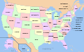
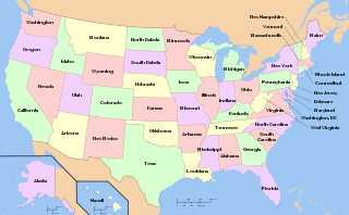
English: A map of the United States, with state names (and Washington D.C.).
|
|
| Date | ||
| Source | see below | |
| Author | The original was edited by User:Andrew c to include Nova Scotia, PEI, Bahamas, and scale key.
It was originally uploaded to the English Wikipedia with the same title by w:User:Wapcaplet:
|
|
| SVG development |
Versions
Non-modifiable text

Clickable

Licensing

|
Permission is granted to copy, distribute and/or modify this document under the terms of the GNU Free Documentation License, Version 1.2 or any later version published by the Free Software Foundation; with no Invariant Sections, no Front-Cover Texts, and no Back-Cover Texts. A copy of the license is included in the section entitled GNU Free Documentation License. |
| This file is licensed under the Creative Commons Attribution-Share Alike 3.0 Unported license. | ||
| ||
| This licensing tag was added to this file as part of the GFDL licensing update. |
|
This file is licensed under the Creative Commons Attribution-Share Alike 3.0 Unported, 2.5 Generic, 2.0 Generic and 1.0 Generic license. | |
|
derivative works
[]

العربية

অসমীয়া

български

বাংলা

বিষ্ণুপ্রিয়া মণিপুরী

bosanski

ᏣᎳᎩ

Ελληνικά
English and all languages

Esperanto

español

eesti

euskara

فارسی

فارسی JPG

suomi

français

galego

Hawaiʻi

hrvatski

עברית

magyar

italiano

ქართული PNG

македонски

മലയാളം

मराठी

Diné bizaad

occitan PNG

ਪੰਜਾਬੀ

polski

português

русский

русский 2

Scots

slovenčina

српски (ћирилица)

svenska

ไทย

اردو

中文(简体)

中文(繁體)


.svg)


derivative works
Derivative works of this file:
File history
Click on a date/time to view the file as it appeared at that time.
(newest | oldest) View (newer 10 | older 10) (10 | 20 | 50 | 100 | 250 | 500)
| Date/Time | Thumbnail | Dimensions | User | Comment | |
|---|---|---|---|---|---|
| current | 00:38, 26 October 2016 | | 959 × 593 (649 KB) | Glrx (talk | contribs) | Try again to fix Kannada versions of Montana, Colorado, and South Dakota |
| 17:36, 22 October 2016 |  | 959 × 593 (649 KB) | Glrx (talk | contribs) | try google translate on failing Kannada Montana, South Dakota, ... | |
| 17:20, 22 October 2016 |  | 959 × 593 (649 KB) | Glrx (talk | contribs) | remove spurious text inside of switch; fix style attribute that did not quote font and left spurious text | |
| 19:26, 17 March 2016 |  | 959 × 593 (649 KB) | Kopiersperre (talk | contribs) | more german translation | |
| 02:50, 26 February 2016 |  | 959 × 593 (664 KB) | Delphi234 (talk | contribs) | Indiana | |
| 01:23, 26 February 2016 |  | 959 × 593 (664 KB) | Delphi234 (talk | contribs) | Aramaic Louisiana, Mississippi, Tennessee, Texas | |
| 01:13, 26 February 2016 |  | 959 × 593 (664 KB) | Delphi234 (talk | contribs) | Arkansas, California | |
| 22:08, 25 February 2016 |  | 959 × 593 (664 KB) | Delphi234 (talk | contribs) | add translations | |
| 05:54, 31 August 2011 |  | 959 × 593 (263 KB) | MissMJ (talk | contribs) | More bug fixing (really hope it works this time -_-'). | |
| 05:52, 31 August 2011 |  | 959 × 593 (263 KB) | MissMJ (talk | contribs) | Bug fix. |
- You cannot overwrite this file.
File usage on Commons
The following 61 pages uses this file:
- Atlas of first-level administrative divisions
- Atlas of the United States
- Maps of North America
- United States
- User:Chumwa/OgreBot/Potential transport maps/2016 February 20-29
- User:Chumwa/OgreBot/Potential transport maps/2016 March 11-20
- User:Kintetsubuffalo/Favorite images
- User talk:Delphi234
- Commons talk:Licensing/Archive 21
- File:EstatsEUA.png
- File:Map of USA MI.svg
- File:Map of USA VT.svg
- File:Map of USA showing state names in Persian.jpg
- File:Map of USA with state names-pt.png
- File:Map of USA with state names.svg
- File:Map of USA with state names 2.svg
- File:Map of USA with state names WLM.svg
- File:Map of USA with state names ar.svg
- File:Map of USA with state names as.svg
- File:Map of USA with state names bg.svg
- File:Map of USA with state names bn.svg
- File:Map of USA with state names bpy.svg
- File:Map of USA with state names bs.svg
- File:Map of USA with state names chr.svg
- File:Map of USA with state names el.svg
- File:Map of USA with state names eo.svg
- File:Map of USA with state names es.svg
- File:Map of USA with state names et.svg
- File:Map of USA with state names eu.svg
- File:Map of USA with state names fa.svg
- File:Map of USA with state names fr.svg
- File:Map of USA with state names gl.svg
- File:Map of USA with state names haw.svg
- File:Map of USA with state names he.svg
- File:Map of USA with state names hr.svg
- File:Map of USA with state names hu.svg
- File:Map of USA with state names it.svg
- File:Map of USA with state names ka.png
- File:Map of USA with state names mk.svg
- File:Map of USA with state names mr.svg
- File:Map of USA with state names nv.svg
- File:Map of USA with state names pt.svg
- File:Map of USA with state names ru(2).svg
- File:Map of USA with state names ru.svg
- File:Map of USA with state names sco.svg
- File:Map of USA with state names sk.svg
- File:Map of USA with state names sr.svg
- File:Map of USA with state names sv.svg
- File:Map of USA with state names th.svg
- File:Map of USA with state names uk.svg
- File:Map of USA with state names ur.svg
- File:Map of USA with state names zh-hans.svg
- File:Map of USA with state names zh-hant.svg
- File:US-deuter.jpg
- File:US-protan.jpg
- File:US-tritan.jpg
- File:USA map with state names pl.svg
- File:US map - states.png
- File:Yhdysvaltain osavaltiot.svg
- Template:Other versions/Map of USA with state names
- Category:States of the United States
File usage on other wikis
The following other wikis use this file:
- Usage on af.wikipedia.org
- Usage on af.wiktionary.org
- Usage on als.wikipedia.org
- Usage on am.wikipedia.org
- Usage on ang.wikipedia.org
- Usage on an.wikipedia.org
- Usage on arc.wikipedia.org
- Usage on ast.wikipedia.org
- Usage on azb.wikipedia.org
- Usage on az.wikipedia.org
- Usage on be.wikipedia.org
- Usage on bi.wikipedia.org
- Usage on bpy.wikipedia.org
- Usage on br.wikipedia.org
- Usage on br.wikiquote.org
- Usage on bs.wikipedia.org
- Usage on bs.wikinews.org
- Usage on ckb.wikipedia.org
- Usage on co.wikipedia.org
- Usage on cs.wikipedia.org
- Usage on cu.wikipedia.org
- Usage on cv.wikipedia.org
- Usage on cy.wikipedia.org
- Usage on da.wikipedia.org
- Usage on de.wikipedia.org
View more global usage of this file.