File:MontAlban TP.jpg
Jump to navigation
Jump to search


Size of this preview: 410 à 600 pixels. Other resolutions: 164 à 240 pixels | 432 à 632 pixels.
Original file (432 Ă 632 pixels, file size: 60 KB, MIME type: image/jpeg)
| Description |
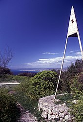
English: Triangulation station on Mont Alban, Nizza/Nice, France. On exposed stations like this, the ground mark is supplemented by an elevated pyramid mark, which can always be used as target from remote points.
Deutsch: Trigonometrischer Punkt bei Nizza
Français : Point gÊodÊsique, Fort du mont Alban, Nice, France. Pour des points exposÊs comme celui-ci, la marque au sol est complÊtÊe par une mire pyramidale surÊlevÊe, qui peut toujours servir de repère depuis des points distants.
|
|||||
| Date | ||||||
| Source | Own work | |||||
| Author | Ikar.us (talk) | |||||
| Permission (Reusing this file) |
I, the copyright holder of this work, hereby publish it under the following license:
|
|||||
| Other versions |
| Camera location | | View this and other nearby images on: OpenStreetMap - Google Earth |
|---|

|
This image has been assessed under the valued image criteria and is considered the most valued image on Commons within the scope: Geodetic control points. You can see its nomination here. |
| Annotations | This image is annotated: View the annotations at Commons |
File history
Click on a date/time to view the file as it appeared at that time.
| Date/Time | Thumbnail | Dimensions | User | Comment | |
|---|---|---|---|---|---|
| current | 22:48, 18 February 2010 |  | 432 à 632 (60 KB) | Ikar.us (talk | contribs) | {{Information |Description={{en|1=en:Triangulation station on Mont Alban, Nizza/Nice, France}} {{de|1=de:Trigonometrischer Punkt bei Nizza}} {{fr|1=fr:Point gÊodÊsique, fr:Fort du Mont Alban}} |Source={{own}} |Author=~~~ |Dat |
- You cannot overwrite this file.
File usage on Commons
The following 5 pages uses this file:
File usage on other wikis
The following other wikis use this file:
- Usage on de.wikipedia.org
- Usage on en.wikipedia.org
- Usage on eo.wikipedia.org
- Usage on fr.wikipedia.org
- Usage on sk.wikipedia.org
