File:NCC-highres.png
Jump to navigation
Jump to search


Size of this preview: 563 × 599 pixels. Other resolutions: 225 × 240 pixels | 451 × 480 pixels | 563 × 600 pixels | 721 × 768 pixels | 962 × 1,024 pixels | 1,854 × 1,974 pixels.
Original file (1,854 × 1,974 pixels, file size: 5.51 MB, MIME type: image/png)
Summary[edit]

|
This image has been assessed under the valued image criteria and is considered the most valued image on Commons within the scope: The National Conference Center. You can see its nomination here. |
| Description |
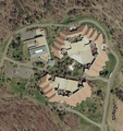
English: Aerial image of The National Conference Center, a corporate training facility in Leesburg, Virginia, United States.
Français : Vue aérienne du National Conference Center, un centre de conférences construit par Xerox en 1974 à Leesburg, en Virginie (États-Unis d'Amérique).
|
|||
| Date | ||||
| Source | USGS The National Map, via MSR Maps (formerly TerraServer-USA) | |||
| Author | United States Geological Survey (USGS) | |||
| Permission (Reusing this file) |
|
|||
| Other versions |
| Camera location | | View this and other nearby images on: OpenStreetMap - Google Earth |
|---|
File history
Click on a date/time to view the file as it appeared at that time.
| Date/Time | Thumbnail | Dimensions | User | Comment | |
|---|---|---|---|---|---|
| current | 17:01, 8 October 2008 |  | 1,854 × 1,974 (5.51 MB) | MBisanz (talk | contribs) | {{Information |Description={{en|1=== Summary == {{Information |Description={{en|1=Aerial map of the National Conference Center}} |Source=http://terraserver-usa.com/usgsentry.aspx?T=4&S=9&Z=18&X=2851&Y=43300&W=3 |Author=USGS |Date=4/7/2002 |Permission= |ot |
- You cannot overwrite this file.
File usage on Commons
The following 6 pages uses this file:
File usage on other wikis
The following other wikis use this file:
- Usage on bn.wikipedia.org
- Usage on en.wikipedia.org
- Usage on si.wikipedia.org
