File:U.S. territorial acquisitions-fr.png
Jump to navigation
Jump to search


Size of this preview: 800 × 542 pixels. Other resolutions: 320 × 217 pixels | 640 × 434 pixels | 1,029 × 697 pixels.
Original file (1,029 × 697 pixels, file size: 183 KB, MIME type: image/png)
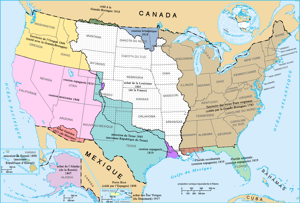
Summary[edit]
French-version map of the territorial acquisitions of the United States.
For the English version, see : Image:USA_territorial_acquisitions.png.
- Sujet : Carte des acquisitions territoriales des États-Unis d'Amérique
- Réalisée par : US Department of Interior
- Source : National Atlas of the United States : http://nationalatlas.gov
- Traduction : par fr:Utilisateur:Sting
Licensing[edit]
This work is in the public domain in the United States because it is a work prepared by an officer or employee of the United States Government as part of that person’s official duties under the terms of Title 17, Chapter 1, Section 105 of the US Code.
Note: This only applies to original works of the Federal Government and not to the work of any individual U.S. state, territory, commonwealth, county, municipality, or any other subdivision. This template also does not apply to postage stamp designs published by the United States Postal Service since 1978. (See § 313.6(C)(1) of Compendium of U.S. Copyright Office Practices). It also does not apply to certain US coins; see The US Mint Terms of Use.
|
 | |
| This file has been identified as being free of known restrictions under copyright law, including all related and neighboring rights. | ||
File history
Click on a date/time to view the file as it appeared at that time.
| Date/Time | Thumbnail | Dimensions | User | Comment | |
|---|---|---|---|---|---|
| current | 17:15, 3 February 2006 | | 1,029 × 697 (183 KB) | Sting (talk | contribs) | French-version map of the territorial acquisitions of the United States. For the English version, see : Image:USA_territorial_acquisitions.png. * '''Sujet :''' Carte des acquisitions territoriales des États-Unis d'Amérique * '''Réalisée pa |
- You cannot overwrite this file.
File usage on Commons
The following 4 pages uses this file:
File usage on other wikis
The following other wikis use this file:
- Usage on fr.wikipedia.org
- Usage on la.wikipedia.org